Navigation for your car is normally a pretty simple affair. Grab a road atlas, find the start point and destination then join up with the biggest roads possible. However, relying on car-based navigation rules will leave you with a pretty hair raising route. In my experience, any road that starts with an 'A' is like visiting Everest's death zone - if you go there, get out quick because you cannot survive there. On a bike, journey time becomes less important than other factors such as - safety, quietness, distance, hills.
So, on a bike there are routes you can't go on, some you won't want to go on, but there are other routes you can take that a car cannot. Route planning for bikes can be quite tricky. Luckily, technology is catching up.
In recent years, people have come together to create the brilliant OpenStreetMap - open map data which people can use to create any type of map. People agree on what data to enter, such as where are all the National Cycle Network routes and then you can create a fabulous map such as the OpenCycleMap .
OpenStreetMap data is now being used in route planning software both online, and in handheld devices. Below, I show you CycleStreets which is getting a lot of publicity, and also the lesser known OpenRouteService .
Demo Route: Cottenham to Cambridge (UK)
Cottenham is 7 miles north of Cambridge. If you look on a map, the obvious route to the centre of Cambridge is directly south on the B1049 and then into the car-restricted central zone.
CycleStreets
CycleStreets shows three different routes. Fastest (red), Balanced (orange) and Quietest (green).
The balanced-orange route is the route most people take, including myself. The fastest-red in this particular example is slightly slower in reality. The quiet-green route is a completely bonkers route in this case.
CycleStreets algorithm does let you do some walking on footpaths which I think would work very well in a city but in the countryside near Cottenham it doesn't. It has routed via a really bumpy, muddy field, then onto a byway which is actually quite pleasant and one I take on the mountain bike. The estimated 40mins for this route is way off. I got similar results on another route.
Overall, however, CycleStreets has a really slick interface and some fab features. I especially like seeing the different routes on the same map.
OpenRouteService
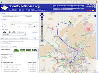
OpenRouteService's bike routing options are Shortest Track; Mountain Bike; Racer; Safest Track; and Preferred Cycle Way.
Shortest track is spot on (as was Cycle Streets). Racer is similar on this route, but on others it really does make a difference - if you have thin wheels, this will keep you more road based, avoiding gravel and footpaths.
Safest and Mountain bike have come up with a really interesting route (pictured). It is 18km long compared to the 11km direct but it is definitely a safer route that I would consider for recreational cycling. Much of the journey is along the guided bus cycle way with a 500m section on gravel to join it. The road choice in Cambridge is pretty good too, taking you via quieter roads rather than the main through roads. A missed opportunity is the even quieter car free section along the river from Chesterton to the city centre, probably only 500m longer.
Conclusions
In my experiments, I found the OpenRouteService came up with better routes and would use that first, but I would always be trying out CycleStreets for cities because it does seem to come up with some really interesting options because it considers walking.
On the road
When out on the bike I use a Garmin Dakota GPS. This will accept a GPX file for a planned route. My favourite road cycling map for the Garmin is VeloMap - this is a free and routeable customised OpenStreet-Map for Garmin GPS devices. Built in is automatic routing for bikes which is really intelligent.


No comments:
Post a Comment